PACCT
Unleashing the Power of Connected Vehicle Data
PACCT is a fully scalable web-based analytics platform for connected car trajectories. The platform can ingest, warehouse, analyze, and visualize billions of connected vehicle datapoints per month. The platform utilizes the latest cloud and distributed computing technologies to dynamically scale the infrastructure based on the cyclical load of datapoints that are received from Wejo.
Transportation Operations Staff can use PACCT to monitor roadway conditions in near real-time and Planners can use it to support data-driven decision making by analyzing recurring congestion or quantifying the effects of roadway improvements
Understand historical trip patterns and monitor travel conditions in near real-time

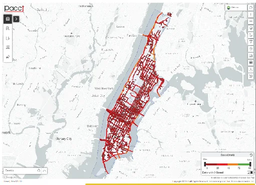
Live Speed Layer
Visualizing your roadway network with our Live Speed Layer will give your Operations Team an unprecedented look at how your roadway network is performing in near real-time.

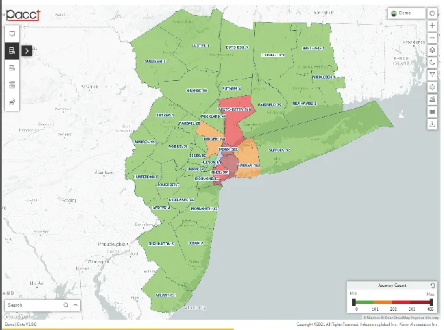
Origin and Destination (O/D)
With PACCT, obtaining accurate insights into the Origins and Destinations for trips is easier than ever. O/D data insights are available at the county, town, point of interest, or custom shapefile level.

Trip Analytics
Transportation Planners can leverage PACCT to understand changes to mobility patterns, conduct before/after studies, and determine safety issues on the roadway network.
Turning Movement Counts
Traffic Engineers can view turning movement percentages and traffic flow maps within PACCT with just a few clicks. With a live feed of Connected Vehicle data, Turning Movements will be available in near-real time.
Reducing Traffic Congestion with Data-Driven Solutions
In today’s world, traffic congestion has a direct impact on the economy. Traffic delays on already overcrowded roadways can occur in a matter of seconds. Traffic Management Centers need more than Dynamic Message Boards and traveler information websites to address recurring and non-recurring congestion. Traffic Planners need constantly updating data as travel patterns change monthly or even daily as motorists adapt to ever changing roadway conditions.
PACCT offers users the ability to make data-driven decisions by leveraging connected vehicle data that has unparalleled accuracy and granularity with low latency. Each of the tools in PACCT was developed with engineers, planners, and operations staff use cases’ in mind to distill the information in a user-friendly and intuitive manner.
Aerolens developed an analytics infrastructure to ingest, process, and render CV data in near real-time. For example, on a daily basis in the Tri-State Region (NY, NJ, CT), the PACCT Platform received and processed approximately:
PER DAY
PER DAY
PER PEAK PERIOD
PER PEAK PERIOD
Vehicle Movement Dataset
- CV Data is precise to +/- 10 feet (under 3 meters) 95% of the time. This can help to identify individual lanes of a highway, back of queue, or even parking spots.
- The Mobility Dataset differs from probe data and other data sources because it is transmitted directly from the vehicle itself. It is more precise, updated more frequently, and has significantly less latency than traditional datasets.
- Data from Connected Vehicles covers better than 95% of roadways in the United States and transmits 24 hours a day, 365 days a year.
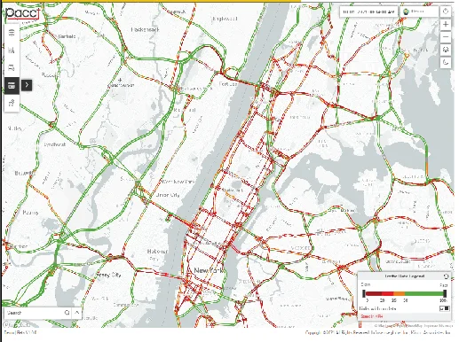
Realtime Conflation and Live Speed Layer
- With this architecture, users can view trip & O/D analytics at the link level, utilize particular links in a pass-through query, and calculate link-based speeds for the live speed layer.
- Operators are able to monitor the roadway network in near-real time and make effective decisions based on the latest available data.
- The Live Speed Layer can also be integrated into open source maps, like OpenStreetMap, or paid mapping services like Google Maps.
Origin and Destination (O/D)
- Each trip is assigned an anonymized unique identifier that allows us to determine the origin and destination.
- The Mobility Dataset differs from probe data and other data sources because it is transmitted directly from the Each GPS point contains geolocation information, direction of travel, and speed. This information is parsed and connected to previous GPS points per trip to create the vehicle’s route.itself. It is more precise, updated more frequently, and has significantly less latency than traditional datasets.
- Multiple spatial aggregations are available for analysis in PACCT. These include county, town, or point of interest levels as well as an option to upload custom zone shapefiles.

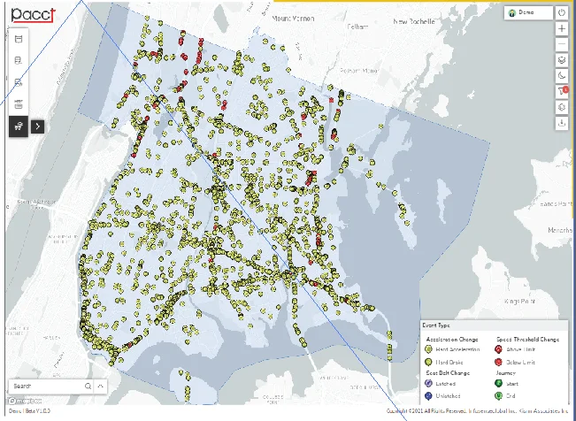
Driver Event Dataset
- The seat belt status, harsh braking, and rapid acceleration events data can be used to determine hazardous roadway conditions or identify potential safety issues.
- Exterior temperature or windshield wiper status can provide explanatory power for harsh braking events during a weather event. The data elements can be used together in this manner to create greater insights.
Turning Movement Counts
- Each trip is assigned an anonymized unique identifier that allows us to determine the origin and destination.
- Each GPS point contains geolocation information, direction of travel, and speed. This information is parsed and connected to previous GPS points per trip to create the vehicle’s route.
- Multiple spatial aggregations are available for analysis in PACCT. These include county, town, or point of interest levels as well as an option to upload custom zone shapefiles.
Get in touch with our experienced experts today. Let's get started!
Infosenseglobal has delivered modern-day technology solutions and enabled business initiatives backed by practised teams. We have facilitated professional support to leading organizations across the world since 2006.
Infosenseglobal has delivered modern-day technology solutions and enabled business initiatives backed by practised teams. We have facilitated professional support to leading organizations across the world since 2006.